Coast takes to the cliff-tops of North Yorkshire’s Cleveland Way footpath to discover epic ocean vistas peppered by dolphins and seals, slivers of beach, and the prettiest seaside villages offering rest and refreshment
Words and Photographs: Paul Miles
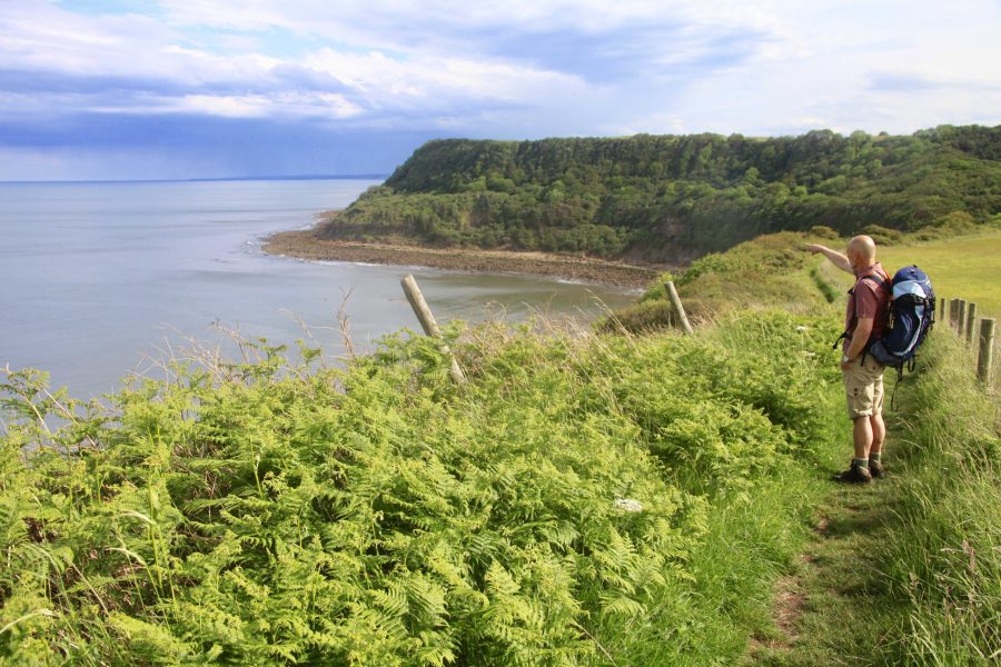
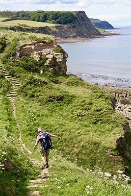
At first, we think we’ve seen a seal. But, from our cliff-top vantage point, we soon realise it’s a dolphin. Then another, and another, as a semicircle of ripples on the sea’s surface moves counter to the waves and seabirds dive. At the waterline there’s a confusion of grey arcs, pale bellies, dorsal fins and spouts from blowholes. Then, clear as anything, a dolphin thwacks a silvery fish into the air. This captivating wildlife spectacle isn’t in some far-flung ocean but the North Sea, visible from Britain’s east coast, five miles north of Scarborough on the Cleveland Way path.
Prior to walking this stretch of the Yorkshire coast, cetaceans had not been on my radar. Seals, yes, for there is a colony of grey seals at Ravenscar, but I was unaware of the news that a pod of bottlenose dolphins had relocated to the neighbourhood. Unique markings have identified them as members of a population from Scotland’s Moray Firth – news that made it into the local press last spring. To see dolphins rounding up fish is great fortune. To see them off the coast of Yorkshire from quiet cow parsley-fringed cliffs is right grand. It turns out that there have even been sightings of humpback whales off this coast, too. And minke whale sightings are fairly commonplace.

v

FOSSILS AND JET
This coastline of the North York Moors National Park is more commonly known for long-dead flora and fauna – the Jurassic era fossils of ammonites, belemnites and fragments of Araucaria (or monkey puzzle) tree, otherwise known as the semi-precious stone, Whitby jet.
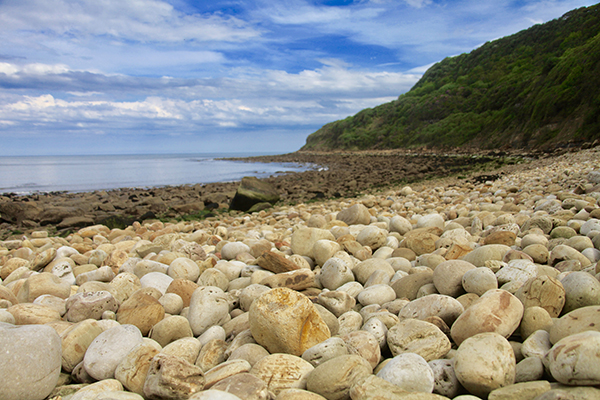
If you fancy fossicking for this blackest of gems – best done after a storm has dislodged material from the cliffs – pack a piece of sandpaper in your rucksack. Counter-intuitively, jet rubs to a ginger dust, while shale rubs grey. Our pockets full of finds from the few beaches to which it’s possible to descend, sadly prove to be nothing more than shale. Shale may be worthless today but for about 300 years, from the 16th century, this grey sedimentary mudstone was quarried and processed to produce alum (potassium aluminium sulphate), used in dyeing and tanning. Until the 16th century, Britain’s supplies of alum came from Italy but, in response to Henry VIII’s break with Rome, the Pope halted exports. So a new British industry was born. Hundreds of men hacked at the cliffs and emptied barrows of the fissile rock into piles to be burnt for months on end. Ponies walked in never-ending circles to winch up barrels of human urine (essential for alum production) from schooners moored close to the cliffs. Inside cliff-top buildings, vats of multi-hued liquor bubbled, evaporated and crystallised. There was acrid smoke, stench and noise.
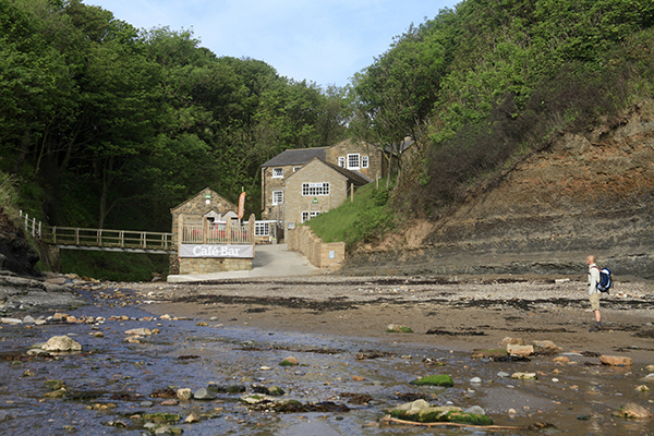
Today, all is peaceful on the windswept cliffs but the long-dead alum industry has shaped the landscape – if you know what to look for. Quarries and spoil heaps are cloaked with gorse and heather. Faint traces of harbours can be seen at low tide. Once-busy alum works have collapsed into ruins. The best preserved is Peak Alum Works, 11 miles north of Scarborough. It’s evening by the time we reach here, having set off at midday from Scarborough train station. After the dolphins (and seals of Ravenscar), some low, crumbling walls seem unremarkable. We hurry on, keen to reach the isolated former mill that is now Boggle Hole youth hostel before it stops serving food. We arrive, footsore, with minutes to spare.
WALKING FROM ROBIN HOOD'S BAY TO WHITBY
Next morning, we continue over the cliffs for a mile to Robin Hood’s Bay, the first proper coastal community since leaving Scarborough, 16 miles south. This area would have been more populated had blink-and-you’ll-miss-it Ravenscar grown into the bustling ‘seaside resort’ that a conniving Victorian developer intended it to be, despite its location on 600ft high cliffs. One or two isolated show-homes are evidence of ‘the town that never was’.
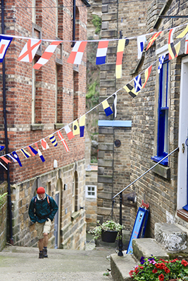
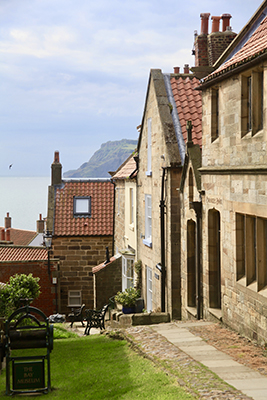
Today in Robin Hood’s Bay former fishermen’s homes sit cheek-by-jowl. Almost every cute cottage is a holiday-let now, thanks to the pretty maze of flowery pedestrian lanes. Here, where tourists wander taking pictures, smugglers once rolled rum barrels and carried crates of tea, although a reputation for smuggling should not detract from a history of more heroic achievements, with hundreds of lives saved by lifeboats launched from the slipway. Even when the village’s own lifeboat was out of action, villagers pulled their weight. During a winter storm in 1881, a cargo ship struck rocks in the bay. Concerned residents called on the Whitby lifeboat to assist. Hundreds of them helped horses haul the lifeboat across snowy cliffs for eight miles, manhandling it through hedges and 6ft drifts until it could finally be lowered into the sea. Volunteers then rescued the crew from the striken brig.

v

Our morning hike across the pasture-topped cliffs towards Whitby is a doddle by comparison. The silhouette of the ruins of Whitby Abbey make for a dramatic welcome to this tourist honey pot. The abbey has re-opened after a £1.6m revamp. The new museum space is impressive, with archaeological finds beautifully displayed but, for my money, a visit to neighbouring St Mary’s Church is quirkier. Its interior is a mind-boggling maze of box pews where whole families can sit, facing each other rather than the minister. There is an upstairs balcony. This compact configuration can seat a total of 1,863 people says Di Davies, the ‘church maid’ who is busy dusting. When I comment that the balcony’s low railings seem precarious, she laughs nervously and recounts the time a large lady nearly toppled over into the congregation below.
CLIFF-TOP WALK TO STAITHES
At the bottom of the famed 199 steps down to the centre of town, Whitby has many charms and not too many day-trippers. We tour the small and fascinating Captain Cook Memorial Museum and salute the statue of him that looks out across the harbour from where he set sail towards the Pacific. We wave to whale-watchers heading to sea in small boats and watch steam trains heading inland to the moors. Next, walking past the Magpie Café, famous for its fish and chips, we stride along the prom with its colourful beach huts onto the sandy seashore towards Sandsend, a straggle of homes, a pub, a couple of cafés and a fine restaurant with rooms, Estbek House.
From Sandsend to
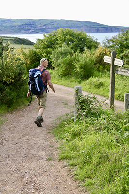
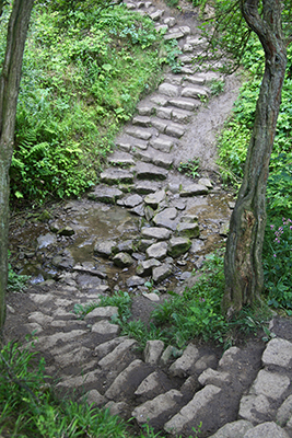
Staithes, the Cleveland Way is again atop the cliffs, running beside fields of crops. Only once does the route lead down to the sea at Runswick Bay where, after a slippery path through a stream, we stroll along the beach. Then it’s uphill through the small village to continue at cliff-top level beside more peaceful fields, some swooping with swifts, until the industrial workings of Boulby polyhalite mine appear on the lower slopes of sparsely populated Boulby cliffs.
In lowering cloud that obscures the 700ft summit, the scene is forbidding, but we stop first to enjoy the homely comforts of tea and scones in the fishing village of Staithes before our mile-long ascent towards those lonely, end-of-the-world cliffs. Our accommodation is a supremely comfortable B&B called Alum House, a former alum works perched a few feet from the cliff’s edge. There’s a hot tub in our private garden with views out to the sea. Dinner is served in our room. After a long day’s arduous hiking, this is the perfect ending. Tomorrow we will be ascending a path that presently disappears into the sky.
NEED TO KNOW
PLANNING A TRIP
The 109-mile-long Cleveland Way, from the inland village of Helmsley to the seaside town of Filey, follows 50 miles of coast, most of it within the North York Moors National Park. The prevailing winds are northerly so it’s usual to walk the route from north to south. coast contributor Paul Miles walked south to north.
To plan a trip go to nationaltrail.co.uk/cleveland-way, where you’ll find itineraries, details of where to stay, and baggage transfer services such as that offered by Trail Magic Baggage, £9 per bag per day (trailmagicbaggage.com).
OS Explorer map OL27 covers most of the route between Scarborough and Saltburn-by-the-Sea. A good guidebook is the North York Moors & Yorkshire Wolds Including York & the Coast, by Mike Bagshaw (£12.99, Bradt Travel Guides).
For more on the area in general, go to northyorkmoors.org.uk.
GETTING THERE
The X4 bus connects Whitby, Sandsend, Runswick Bay, Staithes and Saltburn-by-the-Sea (arrivabus.co.uk).
Filey, Scarborough, Whitby and Saltburn-by-the-Sea all have stations (crosscountrytrains.co.uk, northernrailway.co.uk).
WHERE TO STAY
coast spent one night at the Boggle Hole youth hostel, private en-suite rooms from around £39 per night, refreshments at the Quarterdeck Café & Bar (yha.org.uk/hostel/yha-boggle-hole). The second night was spent at Alum House B&B, Boulby, set in three acres of grounds a mile from Staithes. There are two rooms with private terraces and access to the garden. The Alum suite, with hot tub, costs around £175 per room per night B&B (01287 644088, alumhouseluxurybandb.co.uk).
Coast takes to the cliff-tops of North Yorkshire’s Cleveland Way footpath to discover epic ocean vistas peppered by dolphins and seals, slivers of beach, and the prettiest seaside villages offering rest and refreshment
Words and Photographs: Paul Miles
At first, we think we’ve seen a seal. But, from our cliff-top vantage point, we soon realise it’s a dolphin. Then another, and another, as a semicircle of ripples on the sea’s surface moves counter to the waves and seabirds dive. At the waterline there’s a confusion of grey arcs, pale bellies, dorsal fins and spouts from blowholes. Then, clear as anything, a dolphin thwacks a silvery fish into the air. This captivating wildlife spectacle isn’t in some far-flung ocean but the North Sea, visible from Britain’s east coast, five miles north of Scarborough on the Cleveland Way path.
Prior to walking this stretch of the Yorkshire coast, cetaceans had not been on my radar. Seals, yes, for there is a colony of grey seals at Ravenscar, but I was unaware of the news that a pod of bottlenose dolphins had relocated to the neighbourhood. Unique markings have identified them as members of a population from Scotland’s Moray Firth – news that made it into the local press last spring. To see dolphins rounding up fish is great fortune. To see them off the coast of Yorkshire from quiet cow parsley-fringed cliffs is right grand. It turns out that there have even been sightings of humpback whales off this coast, too. And minke whale sightings are fairly commonplace.
v
FOSSILS AND JET
This coastline of the North York Moors National Park is more commonly known for long-dead flora and fauna – the Jurassic era fossils of ammonites, belemnites and fragments of Araucaria (or monkey puzzle) tree, otherwise known as the semi-precious stone, Whitby jet.
If you fancy fossicking for this blackest of gems – best done after a storm has dislodged material from the cliffs – pack a piece of sandpaper in your rucksack. Counter-intuitively, jet rubs to a ginger dust, while shale rubs grey. Our pockets full of finds from the few beaches to which it’s possible to descend, sadly prove to be nothing more than shale. Shale may be worthless today but for about 300 years, from the 16th century, this grey sedimentary mudstone was quarried and processed to produce alum (potassium aluminium sulphate), used in dyeing and tanning. Until the 16th century, Britain’s supplies of alum came from Italy but, in response to Henry VIII’s break with Rome, the Pope halted exports. So a new British industry was born. Hundreds of men hacked at the cliffs and emptied barrows of the fissile rock into piles to be burnt for months on end. Ponies walked in never-ending circles to winch up barrels of human urine (essential for alum production) from schooners moored close to the cliffs. Inside cliff-top buildings, vats of multi-hued liquor bubbled, evaporated and crystallised. There was acrid smoke, stench and noise.
Today, all is peaceful on the windswept cliffs but the long-dead alum industry has shaped the landscape – if you know what to look for. Quarries and spoil heaps are cloaked with gorse and heather. Faint traces of harbours can be seen at low tide. Once-busy alum works have collapsed into ruins. The best preserved is Peak Alum Works, 11 miles north of Scarborough. It’s evening by the time we reach here, having set off at midday from Scarborough train station. After the dolphins (and seals of Ravenscar), some low, crumbling walls seem unremarkable. We hurry on, keen to reach the isolated former mill that is now Boggle Hole youth hostel before it stops serving food. We arrive, footsore, with minutes to spare.
WALKING FROM ROBIN HOOD'S BAY TO WHITBY
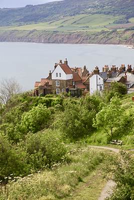
Next morning, we continue over the cliffs for a mile to Robin Hood’s Bay, the first proper coastal community since leaving Scarborough, 16 miles south. This area would have been more populated had blink-and-you’ll-miss-it Ravenscar grown into the bustling ‘seaside resort’ that a conniving Victorian developer intended it to be, despite its location on 600ft high cliffs. One or two isolated show-homes are evidence of ‘the town that never was’.
Today in Robin Hood’s Bay former fishermen’s homes sit cheek-by-jowl. Almost every cute cottage is a holiday-let now, thanks to the pretty maze of flowery pedestrian lanes. Here, where tourists wander taking pictures, smugglers once rolled rum barrels and carried crates of tea, although a reputation for smuggling should not detract from a history of more heroic achievements, with hundreds of lives saved by lifeboats launched from the slipway. Even when the village’s own lifeboat was out of action, villagers pulled their weight. During a winter storm in 1881, a cargo ship struck rocks in the bay. Concerned residents called on the Whitby lifeboat to assist. Hundreds of them helped horses haul the lifeboat across snowy cliffs for eight miles, manhandling it through hedges and 6ft drifts until it could finally be lowered into the sea. Volunteers then rescued the crew from the striken brig.
v
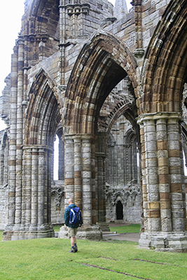
Our morning hike across the pasture-topped cliffs towards Whitby is a doddle by comparison. The silhouette of the ruins of Whitby Abbey make for a dramatic welcome to this tourist honey pot. The abbey has re-opened after a £1.6m revamp. The new museum space is impressive, with archaeological finds beautifully displayed but, for my money, a visit to neighbouring St Mary’s Church is quirkier. Its interior is a mind-boggling maze of box pews where whole families can sit, facing each other rather than the minister. There is an upstairs balcony. This compact configuration can seat a total of 1,863 people says Di Davies, the ‘church maid’ who is busy dusting. When I comment that the balcony’s low railings seem precarious, she laughs nervously and recounts the time a large lady nearly toppled over into the congregation below.
CLIFF-TOP WALK TO STAITHES
At the bottom of the famed 199 steps down to the centre of town, Whitby has many charms and not too many day-trippers. We tour the small and fascinating Captain Cook Memorial Museum and salute the statue of him that looks out across the harbour from where he set sail towards the Pacific. We wave to whale-watchers heading to sea in small boats and watch steam trains heading inland to the moors. Next, walking past the Magpie Café, famous for its fish and chips, we stride along the prom with its colourful beach huts onto the sandy seashore towards Sandsend, a straggle of homes, a pub, a couple of cafés and a fine restaurant with rooms, Estbek House.
From Sandsend to
Staithes, the Cleveland Way is again atop the cliffs, running beside fields of crops. Only once does the route lead down to the sea at Runswick Bay where, after a slippery path through a stream, we stroll along the beach. Then it’s uphill through the small village to continue at cliff-top level beside more peaceful fields, some swooping with swifts, until the industrial workings of Boulby polyhalite mine appear on the lower slopes of sparsely populated Boulby cliffs.
In lowering cloud that obscures the 700ft summit, the scene is forbidding, but we stop first to enjoy the homely comforts of tea and scones in the fishing village of Staithes before our mile-long ascent towards those lonely, end-of-the-world cliffs. Our accommodation is a supremely comfortable B&B called Alum House, a former alum works perched a few feet from the cliff’s edge. There’s a hot tub in our private garden with views out to the sea. Dinner is served in our room. After a long day’s arduous hiking, this is the perfect ending. Tomorrow we will be ascending a path that presently disappears into the sky.
NEED TO KNOW
PLANNING A TRIP
The 109-mile-long Cleveland Way, from the inland village of Helmsley to the seaside town of Filey, follows 50 miles of coast, most of it within the North York Moors National Park. The prevailing winds are northerly so it’s usual to walk the route from north to south. coast contributor Paul Miles walked south to north.
To plan a trip go to nationaltrail.co.uk/cleveland-way, where you’ll find itineraries, details of where to stay, and baggage transfer services such as that offered by Trail Magic Baggage, £9 per bag per day (trailmagicbaggage.com).
OS Explorer map OL27 covers most of the route between Scarborough and Saltburn-by-the-Sea. A good guidebook is the North York Moors & Yorkshire Wolds Including York & the Coast, by Mike Bagshaw (£12.99, Bradt Travel Guides).
For more on the area in general, go to northyorkmoors.org.uk.
GETTING THERE
The X4 bus connects Whitby, Sandsend, Runswick Bay, Staithes and Saltburn-by-the-Sea (arrivabus.co.uk).
Filey, Scarborough, Whitby and Saltburn-by-the-Sea all have stations (crosscountrytrains.co.uk, northernrailway.co.uk).
WHERE TO STAY
coast spent one night at the Boggle Hole youth hostel, private en-suite rooms from around £39 per night, refreshments at the Quarterdeck Café & Bar (yha.org.uk/hostel/yha-boggle-hole). The second night was spent at Alum House B&B, Boulby, set in three acres of grounds a mile from Staithes. There are two rooms with private terraces and access to the garden. The Alum suite, with hot tub, costs around £175 per room per night B&B (01287 644088, alumhouseluxurybandb.co.uk).