STEVE MELIA finds ancient history, empty beaches and conspicuous wealth on a Llyn Peninsula walking route – the northernmost peninsula of Wales.
For many years I have been walking across Britain and parts of Europe using public transport as my means of getting to and from my rambling destination. The main advantage is you don’t have to finish where you started, which is particularly useful for coastal paths.
In some places, a rail journey to the start is part of the attraction. That’s definitely true of the Llyn Peninsula, in north west Wales. On the outward journey I took the Cambrian Line from Birmingham New Street, through mid-Wales, down the River Dovey and along the Gwynedd coast. The views would compare to any I have seen around Britain or Europe.
The Met Office was forecasting weeks of unbroken sunshine when I arrived in Barmouth with my wife. Barmouth is a traditional small seaside town with amusements for children and long queues for fish and chips. We spent a week swimming in the sea, walking inland and admiring the glorious sunsets over its beach, before I continued to Pwllheli, to start my walk around the Llyn Peninsula.
Since my childhood holidays on Llyn, an influx of wealth has altered some parts more than others. In Pwllheli I met my old school friend Geoff, who has been going there for over 50 years, drawn back by its long, quiet beach and because: “Pwllheli is a functioning town. It has schools, businesses and shops for local people, unlike Abersoch.”
Geoff joined me for the first stretch, to Llanbedrog, where we had tea in the glittering new cafe attached to the art gallery.
From Llanbedrog, the coast curves and the path climbs towards the Iron Man sculpture, on a rocky outcrop looking back along the coast we had just walked. The path was bordered with rhododendrons, an invasive non-native species, but a beautiful sight in flower.
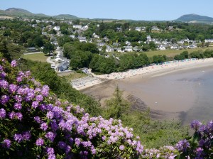
Round the next corner, Abersoch and The Warren beach came into view. Abersoch boasts a power boatyard, high-fashion beachwear shops, classy restaurants and a gastro-pub, where a harassed-looking waitress said she could spare me a table for an hour.
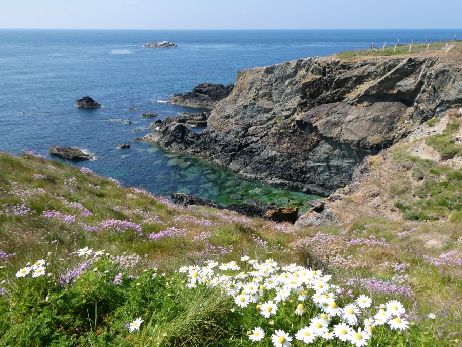
On the fields and farms surrounding Abersoch caravan sites were spreading, with more planned. Thankfully, the National Trust owns much of the land on the next stretch. After Plas yn Rhiw, their 17th-century manor house, the coast they manage is peppered with archaeological remains. It is lightly grazed by ponies and covered by wild flowers of all colours. A pair of choughs was circling overhead when I passed the only two people I saw there.
Aberdaron is smaller than Abersoch, and you are more likely to hear people of all ages speaking Welsh. The National Trust’s information centre explains about the geology, wildlife and history of Llyn, including Tre’r Ceiri hillfort, which I planned to visit later on.
Discover these 10 charming seaside villages and towns to visit in Wales.
There are no coastal settlements, and very little accommodation, for a long way after Aberdaron. I found a camping pod at Penlech, which made for a hard 17 miles, climbing over several hills. Over the next three days I marvelled at the scenery, the empty beaches and the wildlife: the grey seals were the stars.
I spent too long taking photographs and arrived late at the camping pod. The owner looked sympathetic as I struggled to remove my pack, then told me that a young woman who had stayed there recently ran the whole Welsh Coast Path, averaging nearly 40 miles a day, which made me feel much better.
Two days later, I turned off the coast path around the side of Yr Eifl mountain, to head towards Llanaelhaern, where I was staying. Normally, a public footpath means you can walk reasonably safely, staying upright. This was an exception. Some stretches were no wider than a shoe, alongside a near-vertical drop. Then the path went down a cliff, and I had to use my hands, and my backside, to descend.
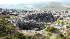
I stayed two nights in Llanaelhaern, to visit the Iron Age hillfort of Tre’r Ceiri nearby. Two of its sides are nearly sheer, so the path to its summit winds around it in an arc. It was worth the 400-metre climb. The walls, Iron Age hut circles and Bronze Age cairn are all still clearly visible, and you can see in all directions, to the sea on both sides of the peninsula.
From Llanaelhearn, the coast path runs along roads, including the main coast road, all the way to Caernarfon. Some of the guide books suggest taking a bus for that stretch but I thought: there must be an inland alternative. There was, but it was longer. It skirted the southern slopes of two mountains towards an old railway line, which is now a cycle and walking path. That also runs alongside a main road to begin with, but then joins a narrow-gauge railway into Caernarfon. I walked 19 miles, the longest, though not the hardest day.
I booked two nights at a pub on the waterfront, next to the castle, which I spent the next day exploring. It is a labyrinth of chambers, walkways, spy holes and dozens of towers served by narrow spiral staircases. Two of the towers house a regimental museum, celebrating the glorious campaigns of the British army against Indian, Chinese and American independence.
On a more serious note, the regiment also kept a goat, not as a mascot, but as a full member. When he behaved well, they gave him champagne, but when he misbehaved on the Queen’s birthday, they demoted him from Lance Corporal to Fusilier.
The final stretch of my walk followed the Menai Straits, under its two historic bridges, into Bangor. The return rail journey was another treat, along beaches and across estuaries. The sun was still shining and all the trains were on time; I felt a rare twinge of regret to be heading home.
CAERNARFON CASTLE AND TOWN WALLS
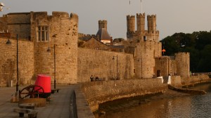
Construction of Caernarfon castle began in 1283, following Edward I’s defeat of Llwelyn ap Gruffudd, the last native Prince of Wales. It is built into the town’s walls, which are mostly still intact.
The walled town initially served as a centre of Anglo-Norman occupation and administration. The Welsh revolted in 1294, seizing and burning the castle. After that revolt was subdued, the castle was repaired and strengthened, although it was never entirely completed – you can still see rough stonework intended for future development in several places.
The interpretation, and some of the modern sculptures on display, reflect Welsh ambivalence towards this symbol of occupation, which is also now a World Heritage Site.
TRE’R CEIRI IRON AGE HILLFORT
At 485 metres, Tre’r Ceiri is one of the highest hillforts in Britain. The footpath leading to it starts from a layby on the B4417 west of Llanaelhearn.
It was built in the Iron Age, incorporating a Bronze Age burial cairn, which the builders respected, leaving its stones intact. Hillforts were sometimes built for defence, but also for religious or ceremonial reasons and sometimes to store surplus food. It remained occupied in the Romano-British period, when some of the circular huts were partitioned, creating smaller spaces, whose purpose is unknown.
A few of the objects recovered from it are in the Storiel Museum in Bangor; the rest are held in storage at the National Museum of Wales, Cardiff.
ACCESSING THE LLYN COAST PATH BY RAIL
The Walk: Wales Coast Path, from Pwllheli to Bangor, 93 miles over seven days of walking, plus three visiting days.
The Cambrian line links Pwllheli and Barmouth to Shrewsbury and Birmingham New Street.
The North Wales Coast line links Bangor to Manchester, Cardiff, Birmingham New Street and London Euston.
Two narrow-gauge heritage railways link the Cambrian line to Caernarfon and, via Blaenau Ffestiniog, to the North Wales Coast Line. festrail.co.uk