Coast is partnering with the Ramblers each month to promote coastal walking. In this month’s column, head of paths JACK CORNISH explains how a deadline is ticking to protect pathways for future generations.
Exploring our coastlines and countryside is much easier when there’s a good coastal walking path to follow, but not every path is recorded, protected or mapped out for others to find easily. We’ve searched all of England and Wales and found over 49,000 miles of paths that could be lost forever unless we claim them as rights of way.
The UK government recently announced it would be implementing a deadline of 2031 to save lost paths in England, despite announcing in 2022 that it wanted to remove the deadline. After that date we will no longer be able to claim rights of way based on historic evidence. The Ramblers want all coastal walking paths that are not on the definitive map to be saved now and for future generations, and we can only do this with your help.
Saving lost coastal walking paths is a long and time-consuming process. Each path application may take weeks to complete and saving all of these paths would be an enormous task, so it’s important that we prioritise saving those that will bring the greatest benefits to walkers. These could be the paths that link you to national walking routes, important landmarks and local history, or that simply allow you to take in breath taking views.
Even paths you know are well used walking routes on your doorstep could be lacking the protection they need to remain open for the next generation. Paths that connect communities, allow people to access green space and improve the equality of walking are too important to risk losing!
You can help us do this by suggesting which paths should be prioritised in your area – simply visit the Ramblers website and pop in your postcode to find the paths that have been identified by you.
That’s why we need as many people as possible to support us and help save these paths before 2031.
The Isle of Wight Ramblers are a great example of how Ramblers volunteers protect paths and help open the way for others. There are over 40 Isle of Wight footpath volunteers who help walkers explore and enjoy the Island’s path network. Why not try one of the Isle of Wight walking routes – from Yarmouth to Freshwater – for yourself?

Starting at the mouth of the West Yar river, this route follows an old island railway track past a historic tidal mill.
After you pass an alder coppice, where trees soak their roots in boggy waters, you’ll notice that the West Yar river constricts and tapers into a small stream. A signposted track leads towards Afton Down, across farmland towards the base of the chalk downlands. Climbing the trail to the highest point of this 7.4-mile walk will reveal stunning views in all directions.
Here you can take in the sights of the iconic Tennyson Monument, gaze out over the Solent towards the New Forest and see the Isle of Wight coastal path stretch out below, following the Old Military Road.
As you descend towards Freshwater, traverse the bay and listen to the sounds of the waves on the shore. Follow the Alum Bay Road to find St Agnes church, which features a rare, thatched roof.
When you reach the path near Afton Marshes, pause at the information boards to see what wildlife lives there, grass snakes or ink cap fungi might be visible depending on the season.
A short amble through a residential area soon brings you back to nature, where your path weaves through swaying reedbeds and atmospheric mires to reach the Causeway.
The route then leads to All Saints’ Church, featuring a sprawling, ancient cemetery, before you reach Kings Manor Farm Shop and the track passes alongside the adjoining farmland.
The final stretch of the route reveals the undulating woodland of Salterns wood, with its wide vistas. It’s the perfect spot to stop and take in the views, especially towards the South. Once you emerge from the woodland, your route will lead you back to Yarmouth. Full details of the walk can be found here: tinyurl.com/3tkk44uc
Read our latest column with the Ramblers here.
Three more to try…
Fancy something closer to home? Check out our three alternative routes:
Llandudno, North Wales
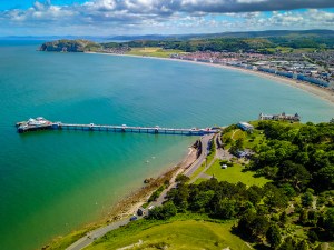
A stunning circuit around a limestone outcrop overlooking Llandudno with spectacular views to Ormes, Ynys Mon and Snowdonia. And if you can take your eyes off the vistas, look out for the wonderful shows of wild flowers including rock rose and spiked speedwell. tinyurl.com/jpt2bufw
Cresswell Beach, Northumberland
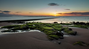
There’s something very special about Cresswell Beach, where families stroll on the wide sands and the remnants of ancient forests peek out of the peaty under-layer. After exploring the beach, you’ll head through Cresswell Pond Nature Reserve before looping back round. tinyurl.com/mvadrtd5
Great Cumbrae, Ayrshire
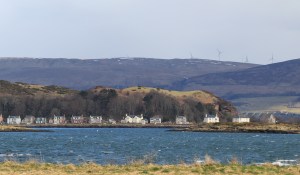
Following the coast and passing over the island’s highest point, this route takes in all Great Cumbrae has to offer from fantastic opportunities to spot local wildlife to local landmarks like Britain’s smallest cathedral. tinyurl.com/3kvbxr6t
Ways you can help to save lost paths
- Join the movement – sign up to emails be the first to hear about progress on the campaign, and ways to get involved.
- Donate – a one-off donation or joining as a Ramblers member can help us develop the online map and the tools we need to build applications for lost paths.
- Volunteer – help us to prioritise, apply for, and save lost paths. There are Rambler’s volunteer roles for everyone, including actions you can take from home.
Find out more at ramblers.org.uk.